Island hopping foundations in chaguaramas trinidad
Island hopping in chaguaramas trinidad begins with understanding its geography. This western Trinidad peninsula curves into the Gulf of Paria, creating a sheltered chaguaramas bay that feels purpose built for small craft and coastal exploration. From here, the wider chaguaramas area opens toward offshore islets that tempt any curious cruising community.
The area of Chaguaramas covers roughly 50 km², framed by hills, forest, and a deeply indented coastline. This setting makes chaguaramas trinidad a natural base for moving between coves, inlets, and nearby islands in both Trinidad and Tobago. Many visitors first arrive via the main road from Port of Spain, passing marinas, shipyards, and the busy commercial port that underline the region’s maritime character.
Historically, chaguaramas in Trinidad has hosted naval bases, regional diplomacy, and trade, and that legacy still shapes the port infrastructure you see today. The signing of the Treaty of Chaguaramas, which established CARICOM, gives the area symbolic weight that contrasts with its relaxed bays and samaan park lawns. For island hoppers, this blend of history and seascape means every short boat ride carries a sense of narrative as well as leisure.
When you plan an island hopping course from chaguaramas bay, think in terms of short segments rather than long offshore passages. The sheltered water and intricate coastline allow you to share time between land based hikes and coastal cruising in a single day. Careful route planning, tide awareness, and respect for conservation rules will help you find quiet anchorages without disturbing sensitive areas.
Planning routes from port of spain to the chaguaramas area
Most island hopping journeys into chaguaramas trinidad start in or near Port of Spain. The drive along the western main road traces the shoreline, where each bend opens a new window onto the bay and its moored yachts. As you approach the area of Chaguaramas, marinas, boatyards, and the formal port facilities signal that you are entering the country’s primary recreational maritime hub.
For independent travelers, the valley road into Tucker Valley offers a contrasting inland route. Here, samaan park and the surrounding green areas provide a calm prelude before you reach the water again at macqueripe bay or williams bay. Many visitors combine a morning hike with an afternoon swim, using the road network as a flexible framework for a multi stop day.
Island hoppers arriving by yacht often share information through the cruising community, both dockside and online. Local marinas near port of spain and within the chaguaramas area maintain noticeboards, charts, and courtesy briefings on anchorages, currents, and regulations. This culture of shared knowledge helps newcomers find safe routes and understand which areas are best suited to day trips versus overnight stays.
To deepen your planning skills, it is useful to compare chaguaramas trinidad with other island hopping destinations. Guides to places such as the Wisdom Path and Lantau Island show how walking trails, viewpoints, and ferry routes can be woven into a coherent itinerary. Applying similar thinking here will help you structure days that balance road transfers, short crossings, and time ashore.
Water based experiences around macqueripe bay and williams bay
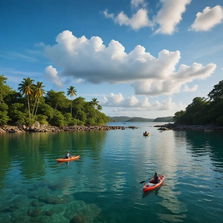
The sheltered coves of western Trinidad make chaguaramas trinidad ideal for water based island hopping. Macqueripe bay, enclosed by steep forested slopes, offers clear water for swimming and snorkeling, along with a small beach that feels surprisingly secluded given its proximity to the main road. Nearby williams bay provides a more open curve of sand, where families gather and small boats shuttle between the shore and moorings.
From these bays, you can arrange short boat transfers to nearby islets or simply cruise along the coastline to appreciate the changing character of each area. Kayakers often follow the line of the cliffs, where every turn opens a fresh window onto rock formations, mangroves, and small landing spots. When conditions are calm, stand up paddleboarding offers another way to share the water with local wildlife while keeping your environmental footprint light.
Safety remains central to any water focused itinerary in chaguaramas trinidad. Check local guidance on currents, restricted areas, and weather before setting out, especially if you plan to cross toward offshore islands in Trinidad and Tobago. Many operators in the chaguaramas area provide equipment, guides, and courtesy briefings, which can be particularly valuable if you are new to these waters or traveling with children.
For travelers comparing different archipelagos, a detailed island hopping guide to the Faroe Islands illustrates how variable conditions can shape daily decisions. Applying that mindset here means remaining flexible, adjusting your course chaguaramas wide according to wind, swell, and visibility. In doing so, you preserve both safety and the sense of calm that defines these bays.
Hiking tucker valley, bamboo cathedral, and samaan park
Island hopping around chaguaramas trinidad is not limited to boats and bays. Tucker Valley, reached via the valley road branching from the main road, offers a network of trails that complement time on the water. Many travelers alternate days between coastal cruising and inland hiking, using the same chaguaramas area as a base.
The celebrated bamboo cathedral forms one of the region’s most atmospheric walks. Here, towering bamboo on either side of the path bends inward, creating a natural archway that feels like an opens window into another world. This route, often combined with visits to samaan park and nearby edith falls, allows you to experience the ecological diversity that underpins western Trinidad.
Along these trails, interpretive signs and local guides share insights into the flora, fauna, and history of chaguaramas trinidad. You may pass remnants of old military installations, reminders that this peaceful valley once played a strategic role in regional defense. Today, the focus has shifted toward conservation, with hunting prohibited and visitors encouraged to stay on marked paths to protect sensitive areas.
For island hoppers used to purely coastal itineraries, this blend of forest, falls, and open parkland adds welcome variety. It also mirrors patterns seen in other destinations, where inland hikes complement shoreline exploration, as in many multi bay beach itineraries. By structuring your days to include both water and land based experiences, you gain a more complete sense of the chaguaramas area and its role within Trinidad and Tobago.
Golf course, marinas, and the cruising community culture
Beyond its natural assets, chaguaramas trinidad offers a developed recreational infrastructure that supports extended island hopping stays. The local golf course in the chaguaramas area, set against a backdrop of hills and sea views, provides a different kind of course chaguaramas experience between sailing days. Nearby marinas line the bay, where yachts from Trinidad, Tobago, and farther afield form a floating village.
This concentration of vessels has fostered a strong cruising community, with sailors who arrived years ago often choosing to remain seasonally or long term. On any given evening, you may hear conversations that range from maintenance tips to stories of passages between Trinidad and Tobago, or onward to other Caribbean ports. Informal gatherings on decks and in waterfront cafés encourage visitors to share charts, waypoints, and recommendations for lesser known areas.
From a practical standpoint, the port facilities in chaguaramas trinidad offer haul out services, chandlers, and repair yards that are rare elsewhere in western Trinidad. This makes the bay a logical place to prepare a vessel for more ambitious island hopping, whether north toward the Grenadines or west along the South American coast. Even travelers staying on land benefit from this maritime ecosystem, as it supports a range of water based excursions and training courses.
Social media also plays a role in how information circulates within the area chaguaramas. Many marinas maintain active Facebook pages where they share updates on events, safety notices, and courtesy reminders about environmental regulations. Following these channels before and during your trip helps you find current information that complements charts and guidebooks.
Practical guidance, conservation, and responsible sharing of chaguaramas
Responsible island hopping in chaguaramas trinidad requires attention to both logistics and conservation. Before you travel, contact the Chaguaramas Development Authority (CDA) at [email protected] for the latest guidance on access, fees, and any restricted areas. Their oversight of the chaguaramas area ensures that recreational use remains compatible with habitat protection and historical preservation.
On the water, respect no wake zones, marked channels, and designated moorings, especially near macqueripe bay, williams bay, and other sensitive areas. Avoid anchoring on coral or seagrass, and keep a careful course when passing close to shore, where turtles and other marine life may surface unexpectedly. On land, follow posted rules in samaan park, the bamboo cathedral, and around edith falls, where erosion and litter can quickly degrade fragile environments.
When you share images or stories of chaguaramas trinidad online, consider how your posts might influence future visitor behavior. Geotagging remote spots can lead to sudden pressure on small bays or trails, so some travelers choose to describe areas more generally while still conveying their experience. Platforms such as Facebook remain useful for connecting with local operators and the cruising community, but thoughtful posting helps protect the very qualities that make these places special.
As one local authority notes, "Chaguaramas has been a site for various historical events, including Columbus' visit in 1498, the British conquest in 1797, and the signing of the Treaty of Chaguaramas in 1973, which established CARICOM." Keeping this layered history in mind adds depth to each window that opens onto the bay, each road that curves toward the port, and each quiet anchorage you find. In doing so, you engage with chaguaramas trinidad not only as a scenic playground but as a living chapter in the story of Trinidad and Tobago.
Key statistics for island hopping in chaguaramas trinidad
- Approximate area of Chaguaramas region : 50 km² managed for mixed recreation and conservation.
- Elevation of nearby Chacachacare Lighthouse : around 251 meters above sea level, offering wide views of surrounding waters.
- Chaguaramas lies near coordinates 10.6833° N, 61.6333° W on Trinidad’s northwest peninsula.
Essential questions about chaguaramas trinidad for island hoppers
What is the historical significance of chaguaramas for travelers?
Chaguaramas has long held strategic and diplomatic importance within Trinidad and Tobago, which adds context to any island hopping itinerary. It served as a military base area during major global conflicts and later hosted the signing of the Treaty of Chaguaramas that created CARICOM. When you move between bays, trails, and port facilities today, you are traveling through a landscape shaped by centuries of maritime, colonial, and regional history.
Which activities best suit an island hopping stay in chaguaramas trinidad?
Visitors can combine coastal and inland experiences in a compact area, which suits flexible island hopping plans. Popular options include kayaking, snorkeling, and swimming in macqueripe bay or williams bay, along with hiking to the bamboo cathedral, exploring Tucker Valley, and relaxing in samaan park. Many travelers also integrate short cultural visits to nearby Port of Spain, creating a balanced mix of nature, recreation, and urban flavor.
Are there specific conservation rules island hoppers should know?
Yes, conservation regulations are central to how chaguaramas trinidad is managed for recreation. Hunting is prohibited, and visitors are expected to stay on marked trails, respect wildlife, and avoid damaging vegetation, especially in forested areas and around edith falls. On the water, adherence to designated moorings, speed limits, and waste disposal rules helps protect marine habitats and ensures that the bay remains welcoming for future travelers.
