Understanding where Utila is located in the Caribbean seascape
To understand where Utila is located, start with a map of Central America. Just off the northern coast of Honduras, this small island rests in the Caribbean Sea, forming part of the Bay Islands archipelago. The municipality of Utila is administered within the Islas de la Bahía department, giving the island a distinct identity yet strong ties to mainland Honduras.
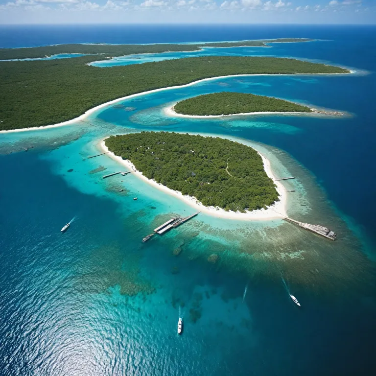
Utila island lies at approximately 16.1° north and 86.9° west, a compact landmass of about 45 km² with a low elevation that keeps you close to the water at all times. When travellers speak about isla Utila, they often compare its relaxed atmosphere with the busier islands of Roatán or the more remote Guanaja, yet all three Bay Islands share the same barrier reef system. Knowing precisely where Utila Honduras sits helps you plan ferry connections, regional flights, and multi island itineraries that may also include Belize City or San Pedro in Belize.
From a broader perspective, Utila belongs to the western Caribbean, roughly aligned with major cruise routes that run between Mexico, Belize, and Honduras. Many visitors first land in San Pedro Sula on the mainland, then continue by domestic flight or shuttle to the ferry terminal that serves island Utila and its neighbouring islands. This position makes Utila a strategic stop for anyone interested in combining reef focused scuba diving, relaxed beach time, and cultural encounters across Central America.
How Utila’s location shapes island hopping routes and access
Because of where Utila is located, access is easier than many travellers expect. The island is served by Utila Airport, which handles regional flights that often route through San Pedro Sula or occasionally through other Central America hubs. For many, the journey becomes part of the fun, combining a short domestic flight with a scenic ferry crossing through the Bay Islands.
The main maritime gateway is the ferry from the Honduran mainland, which connects the bay to isla Utila several times per week. Travellers arriving from cruise ships that dock elsewhere in the Bay Islands sometimes add a side trip to Utila island, especially if they want quieter beaches and more intimate dive sites. When planning islands combinations, some itineraries link Utila Honduras with Belize City or San Pedro via regional airlines, creating a chain of Caribbean islands that share the same barrier reef system.
Once you arrive on island Utila, movement is charmingly small scale and low impact. The main street runs along the waterfront, and many visitors rent a golf cart or bicycle to move between the harbour, Chepes Beach, and the western dive shops. This compact layout, combined with the island’s modest population of just over five thousand people, means your travel time between accommodation, reef, and beach is measured in minutes rather than hours.
The marine geography that makes Utila a world class dive hub
Understanding where Utila is located also means understanding the underwater world that surrounds it. The island sits along the southern edge of the Mesoamerican Barrier Reef, the second largest barrier reef on the planet after Australia’s Great Barrier Reef. This reef system stretches past the Bay Islands towards Belize City and San Pedro, creating a continuous chain of coral, seagrass, and deep walls that attract marine life.
Utila’s position on the edge of deep Caribbean water creates exceptional conditions for both diving and snorkelling. The island’s many dive sites lie only a short boat ride from the main street, and local dive shops reach vertical walls, shallow coral gardens, and sandy bays within minutes. It is no exaggeration that Utila is recognized as one of the world's best dive locations, and the island is increasingly attracting tourists interested in scuba diving and marine life exploration.
Calm seas, warm water, and generally excellent visibility make scuba diving around isla Utila accessible for beginners yet rewarding for advanced divers. The reef around Utila Honduras hosts turtles, eagle rays, and dense schools of reef fish, while deeper water channels occasionally bring in whale sharks. For island hopping travellers, this marine geography means you can plan several islands in one trip yet still treat Utila as your main base for intensive dive time.
Life on Utila: main street, beaches, and inland hills
Once you know where Utila is located, the character of daily life on the island becomes easier to picture. The settlement hugs the southern shore, with the main street tracing the curve of the bay and opening onto small docks, cafes, and low key guesthouses. This waterfront strip is where island utila feels most alive, as dive shops brief their teams, ferries arrive, and golf cart traffic weaves between pedestrians.
Chepes Beach, at the western end of town, is the most popular public beach on Utila island. Its shallow water and gentle waves make it ideal for relaxed swimming after a morning of scuba diving or snorkelling on nearby reef patches. Further along the coast, quieter bays and small beaches provide more privacy, especially for travellers who highly recommend unhurried afternoons with a book and the sound of the Caribbean.
Inland, the terrain rises gently towards Pumpkin Hill, the island’s highest point at around 74 meters. A walk or golf cart ride to Pumpkin Hill opens window like views over the Bay Islands and the surrounding Caribbean Sea, especially on clear days. From this vantage, you can appreciate how compact isla Utila really is, and how closely the town, reef, and interior hills sit together within the wider geography of Honduras and Central America.
Island hopping strategies linking Utila with other Caribbean islands
Knowing precisely where Utila is located allows you to design efficient island hopping routes. Many travellers begin in San Pedro Sula, then move by road to the ferry that serves the Bay Islands, using Utila as their first island stop. Others fly between Belize City, San Pedro, and Honduras, stitching together several islands along the barrier reef for a longer Caribbean journey.
For those who enjoy structured travel planning, it helps to treat isla Utila as the main hub for scuba diving and relaxed beach time. From here, you can add day trips to neighbouring Bay Islands or extend your route to other Caribbean islands that share similar reef systems. Resources such as this elegant guide to the Spanish Virgin Islands (island hopping through the Spanish Virgin Islands) show how different archipelagos can be combined into one coherent island hopping narrative.
On Utila island itself, island hopping often becomes reef hopping, as dive boats move between multiple dive sites in a single day. Local dive shops and operators such as Underwater Vision coordinate schedules so that boats spread out across the reef, keeping sites uncrowded and the experience enjoyable. Whether you arrive by cruise, ferry, or regional flight, the combination of short travel times, compact geography, and varied marine environments makes island utila a highly recommend base for wider Caribbean exploration.
Practical tips for time, money, and safety on Utila
Because of where Utila is located and its small scale, practical planning is straightforward yet still deserves attention. The island’s population of around 5,215 people supports a tourism economy focused on scuba diving, water sports, and relaxed Caribbean living. Most services cluster along the main street, where you will find dive shops, small supermarkets, and places to arrange golf cart rentals or boat transfers to remote bays.
When it comes to money, bring a mix of cash and cards, as not every business accepts credit payments and ATMs can occasionally run low. Many travellers allocate most of their budget to diving, as multi day packages with several dive sites per day offer excellent value compared with other Caribbean islands. Time your travel to allow at least several days on isla Utila, especially if you plan to complete a scuba diving course or explore Pumpkin Hill and Chepes Beach between dives.
Safety on Utila island is generally good, but standard Central America travel precautions still apply, particularly when arriving late by ferry or transiting through San Pedro Sula or San Juan on the mainland. If you are connecting from a cruise or long haul flight, allow buffer time in case of weather related delays on the bay. Utila is accessible via Utila Airport, which handles regional and international air traffic, and is also reachable by ferry from the mainland.
Key statistics that highlight Utila’s scale and setting
- Approximate area of Utila island : 45 km² of land surrounded by Caribbean reef.
- Estimated population of Utila : about 5,215 residents supporting tourism and fishing.
- Maximum elevation near Pumpkin Hill : roughly 74 meters above sea level.
- Geographical coordinates of isla Utila : close to 16.1° N latitude and 86.9° W longitude.
- Utila is known for its favorable diving conditions and numerous dive sites.
Essential questions travellers ask about Utila
What is Utila known for?
What is Utila known for? Utila is renowned for its favorable diving conditions, extensive coral reefs, and diverse marine life, including the elusive whale shark. This reputation makes the island a central stop for scuba diving enthusiasts planning island hopping routes across the Bay Islands and wider Caribbean.
How can I get to Utila?
How can I get to Utila? Utila is accessible via Utila Airport, which handles regional and international air traffic, and is also reachable by ferry from the mainland. Many travellers route through San Pedro Sula or other Central America hubs before continuing by domestic flight or ferry to isla Utila.
What is the population of Utila?
What is the population of Utila? As of 2023, the estimated population of Utila is 5,215 people. This relatively small community contributes to the island’s intimate atmosphere, where main street life, dive operations, and local culture remain closely intertwined.
