Charting elegant sailing routes for meaningful island hopping
Sailing routes for island hopping begin with understanding how oceans breathe. When you plan any sailing itinerary, you align your route with trade winds, currents, and safe anchorages, which turns a simple sail into a structured voyage. Thoughtful cruising routes also respect time, weather, and the long distance realities between islands.
Historically, navigators shaped many modern sailing routes by reading stars and swells. Ferdinand Magellan’s passage through the Strait of Magellan and Hendrik Brouwer’s south route across the Indian Ocean both showed how a well chosen route could shorten time at sea and open new cruising destinations. Today, modern yachts and catamarans still follow these patterns, using GPS and electronic charts to refine each route sailing plan.
For contemporary island hopping, your voyage planner should integrate north and south seasonal shifts. In the north Atlantic and west indies, winter trade winds favour a westbound sail, while the south atlantic and indian ocean often reward a more cautious approach due to long swell and fewer harbours. Many skippers still consult jimmy Cornell and his routes edition guides, because jimmy cornell compiled data on weather, currents, and optimal time windows.
When you design your own sailing routes, think in connected arcs rather than isolated hops. A well structured route might link the canary islands, the west indies, and onward cruising routes through the panama canal into the pacific, each leg shaped by reliable trade winds. This approach mirrors how long distance sailors plan three years ahead, balancing ambition with realistic time frames and vessel capability.
Designing an island hopping itinerary around wind, weather, and vessel type
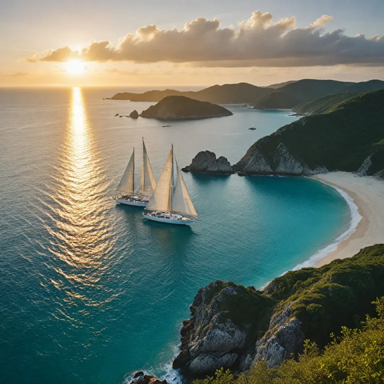
Every refined island hopping itinerary starts with the vessel and crew. A performance yacht can comfortably manage longer route sailing legs between remote islands, while a cruising catamaran may prioritise comfort at anchor and generous living space. Matching your sailing routes to your yacht or catamaran means you respect both safety margins and the pleasure of unhurried cruising.
Weather is the quiet architect of all successful cruising routes. In the north Atlantic, winter trade winds support a classic canary islands to west indies route, while the south atlantic often demands careful timing to avoid strong headwinds and confused seas. In the pacific, long distance passages between archipelagos require a voyage planner that integrates cyclone seasons, prevailing winds, and the limited shelter options on some islands.
Many experienced sailors still rely on cornell sailing resources when shaping a multi ocean itinerary. The routes edition by jimmy cornell analyses seasonal windows for the indian ocean, the red sea, and even challenging passages near cape horn, helping skippers judge when a route is realistic for their crew. This level of planning is essential if you intend to spend three years or more exploring multiple cruising destinations by sail.
Historical achievements also inform modern expectations about time and endurance. Francis Chichester and Robin Knox Johnston both used clipper style sailing routes that exploited trade winds and currents, proving how efficient a well chosen route can be. When you plan an elegant island hopping journey from the united states to the adriatic, resources such as this detailed Dubrovnik to Split cruise experience help translate ocean scale planning into human scale coastal itineraries.
From atlantic arcs to pacific passages: structuring long distance island chains
Island hopping across oceans requires thinking in stages rather than isolated holidays. A classic long distance plan might begin with a sail from the united states east coast to the canary islands, then follow established sailing routes across the atlantic to the west indies. From there, many cruising routes continue through the panama canal into the pacific, where the scale of islands and time at sea increases dramatically.
In the south pacific, route sailing between archipelagos demands respect for weather and remoteness. Trade winds usually support a westward itinerary, but the long gaps between islands mean your yacht or catamaran must be fully prepared, with redundancy in navigation, power, and safety systems. A careful voyage planner will also consider the south east trades near zealand australia, where seasons and currents shift as you move toward higher latitudes.
The indian ocean and red sea introduce different challenges for island hopping enthusiasts. Here, jimmy cornell and other experts emphasise the importance of timing routes to avoid cyclone seasons and adverse monsoon patterns, especially on long passages between cruising destinations. Many sailors allocate up to three years for a full circuit that includes the south atlantic, indian ocean, and pacific, allowing generous time for both passage making and extended stays on key islands.
Not all island hopping needs to span oceans to feel meaningful and refined. Coastal archipelagos, such as Italy’s Cinque Terre, offer compact yet intricate sailing routes where short hops reveal dramatic landscapes and historic villages. For inspiration on shaping such a coastal itinerary, this guide to Italy’s coastal gems illustrates how even modest routes can feel like a curated voyage.
Regional character: atlantic, indian, and pacific island hopping compared
Each ocean basin lends a distinct character to island focused sailing routes. In the north and south atlantic, the combination of trade winds and established harbours makes route sailing relatively structured, especially along the canary islands to west indies arc. Here, cruising routes often follow patterns refined over centuries, from early explorers to modern cornell sailing inspired planners.
The indian ocean offers fewer islands but powerful cultural and historical depth. Cruising destinations along this route include archipelagos off east Africa, the Maldives, and island groups leading toward south east Asia, each separated by long stretches of open water. A prudent voyage planner will integrate jimmy cornell data on monsoon shifts, piracy risk zones, and the practicalities of transiting the red sea toward the Mediterranean.
In the pacific, scale becomes the defining factor for any itinerary. Long distance passages between island chains demand robust yachts or catamarans, conservative weather routing, and realistic time expectations, especially if your overall plan spans three years or more. Many sailors treat the pacific as a series of regional circuits, using flexible sailing routes that adapt to seasonal windows and personal interests.
Southern high latitude routes, including those near cape horn, remain the domain of highly experienced crews. While not typical for relaxed island hopping, these routes influence how we understand weather systems that feed into more temperate cruising destinations. For travellers seeking a gentler yet still adventurous experience, curated guides such as this article on island hopping through emerald bays show how to balance ambition with comfort and cultural immersion.
Safety, regulations, and responsible seamanship along popular sailing routes
Responsible island hopping requires more than an attractive itinerary on paper. Before committing to any long distance sailing routes, ensure your yacht or catamaran complies with international safety standards, carries updated charts, and has reliable communication equipment for offshore legs. Modern voyage planner tools integrate GPS, satellite weather, and regulatory information, but prudent skippers still cross check with official notices and pilot books.
Weather awareness remains central to safe cruising routes. Be aware of seasonal weather patterns and potential hazards along each route, and remember that localised effects near islands can accelerate wind or create confused seas. Many sailors still blend traditional seamanship with digital tools, using barometer trends, cloud patterns, and sea state to validate electronic forecasts before committing to a long route sailing leg.
Regulatory considerations vary widely between cruising destinations. Ensure compliance with international maritime regulations and obtain necessary permits, especially when transiting sensitive areas such as the red sea or environmentally protected islands. Some regions between south africa and the indian ocean islands, or along the united states coasts, also require advance notice of arrival, safety inspections, or specific equipment for yachts and catamarans.
Geopolitical awareness is another pillar of trustworthy planning. Stay informed about geopolitical situations that may affect certain routes, particularly in choke points or regions with evolving security conditions. When in doubt, many skippers consult cornell sailing publications, jimmy cornell updates, and local cruising associations, then adjust their sailing routes or timing to maintain a wide safety margin while still honouring their broader three years exploration plan.
Planning tools, timelines, and expert references for refined island hopping
Transforming an island hopping dream into a coherent voyage requires structured planning. A dedicated voyage planner helps you map sailing routes across oceans, align them with realistic time frames, and integrate personal priorities such as cultural stops or quiet anchorages. Many long distance sailors sketch a three years outline, then refine each route edition as weather data, vessel performance, and personal experience accumulate.
Modern tools complement, rather than replace, authoritative references. Publications by jimmy cornell, including the well known routes edition, synthesise decades of data on trade winds, currents, and seasonal windows across the atlantic, pacific, and indian ocean. Digital platforms now layer this information with real time weather, allowing skippers to adjust cruising routes between islands, the united states coasts, south africa, and zealand australia with greater confidence.
Historical context also enriches your planning mindset. The timeline of major maritime milestones shows how innovation, from the Suez and Panama canals to modern ice capable vessels, has reshaped route sailing options. As one expert summary notes, “The Suez Canal, completed in 1869, provided a direct maritime route between Europe and Asia, significantly reducing travel time and boosting global trade efficiency.”
Finally, cultivate a reflective approach to every itinerary. After each leg between islands, review how your yacht or catamaran handled the weather, whether your time estimates were accurate, and how well your chosen sailing routes matched your expectations for comfort and engagement. Over months and years, this habit turns a simple cruising plan into a sophisticated, personally tailored atlas of routes that balances ambition, safety, and the quiet luxury of unhurried time at sea.
Key statistics shaping modern sailing routes
- Length of the Suez Canal: 193.3 kilometres, linking the Mediterranean and Red Sea.
- Annual ship traffic through the Suez Canal: approximately 19 000 ships transit each year.
- Percentage of world trade passing through the Suez Canal: about 12 percent of global volume.
- Annual ship traffic through the Panama Canal: around 14 000 ships use this route annually.
- Reduction in distance using the Northern Sea Route from Murmansk to Yokohama: about 7 070 nautical miles saved compared with traditional passages.
Essential questions about historical and modern sailing routes
What is the significance of the Strait of Magellan ?
The Strait of Magellan is a navigable sea route in southern Chile that separates mainland South America to the north and the Tierra del Fuego archipelago to the south. It was first navigated by Europeans in 1520 during Ferdinand Magellan's expedition. For modern sailors, it remains a demanding alternative to cape horn, illustrating how geography still shapes strategic sailing routes.
How did the Suez Canal impact global trade ?
The Suez Canal, completed in 1869, provided a direct maritime route between Europe and Asia, significantly reducing travel time and boosting global trade efficiency. By eliminating the need to sail around the south of Africa, it shortened traditional sailing routes and reshaped cruising destinations for both commercial and private vessels. Today, many long distance itineraries for yachts and catamarans integrate Suez as a pivotal link between the Mediterranean and the indian ocean.
What challenges are associated with the Northern Sea Route ?
The Northern Sea Route offers a shorter passage between Europe and Asia but presents challenges such as harsh weather conditions, ice navigation, and limited infrastructure. Even with modern ice capable ships and satellite navigation, the window for safe passage remains narrow, and support services are sparse. For most island hopping sailors, these factors make the route more of a strategic commercial corridor than a practical cruising option.
